top of page
Search

Designing with Water: A New Blueprint for South Florida

  • Writer: Aaron DeMayo
    Aaron DeMayo
  • 5 days ago
  • 3 min read

You are invited to join us for an honest and optimistic look at the future of our region. Next Saturday, February 28th, Future Vision Studios is hosting a session at the Perez Art Museum Miami (PAMM) to present a data-driven roadmap for a resilient City. As part of Open House Miami 2026, we are showcasing how South Florida can adapt and thrive given the changing climate and weather events. This session focuses on real strategies that directly impact our zoning, insurance markets, and historic districts.


We will be presenting three specific frameworks—Buoyant City, Salty Urbanism, and The Coastline. Together, these projects represent a blueprint for how development, historic preservation, and regional infrastructure can evolve to protect our community and create new public park space.


Three Frameworks for Adaptation

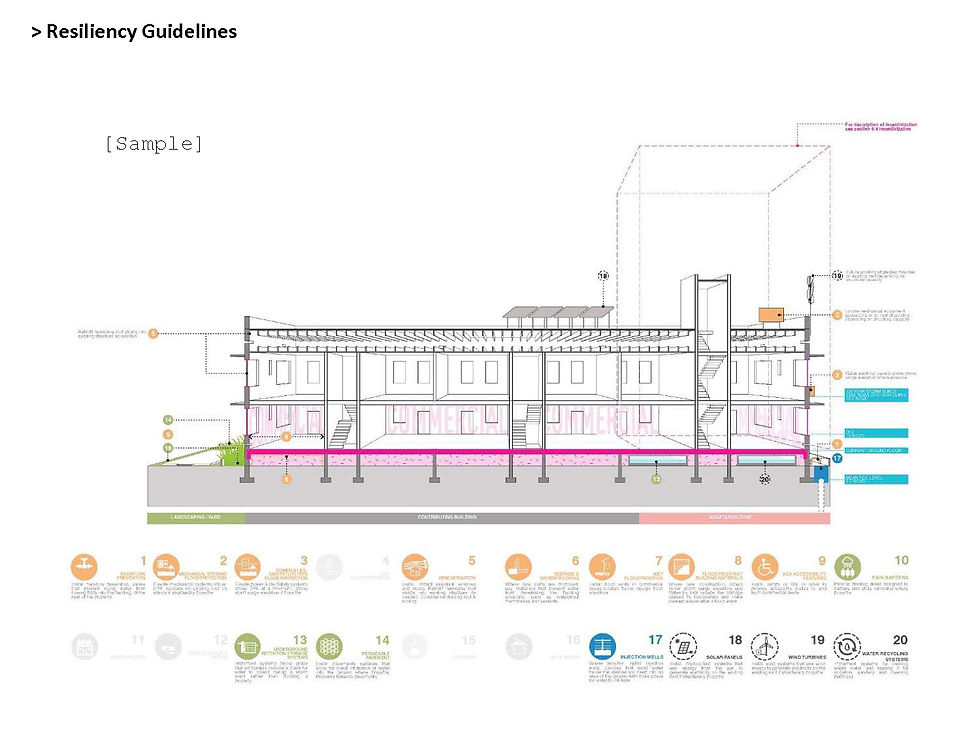
  • Buoyant City (Allan Shulman, FAIA): This framework focuses on historic districts like South Beach. It proposes active preservation strategies, such as elevating structures and adapting ground floors, to allow heritage neighborhoods to evolve without losing their identity.

The book cover for "Buoyant City: Historic District Resiliency & Adaptation Guidelines, Miami Beach." The design features a clean white background with a grid of bright pink circles, each containing a different white line drawing of a historic building type. The title and subtitle are displayed in the center in a modern sans-serif font.
Buoyant City: Historic District Resiliency & Adaptation Guidelines (2021)
An architectural rendering titled "Vision of a designated historic district in continuous growth." The image shows a street-level view of a residential neighborhood where traditional two-story white buildings have been adapted with modern, multi-story glass and greenery-filled additions on top. A quote by Gustavo F. Araoz about "preserving the ability to change" is overlaid on a soft pink sky. Pedestrians, children, and people walking dogs are seen on the sidewalk in the foreground.
Buoyant City: Historic District Resiliency & Adaptation Guidelines (2021)
A technical planning diagram from "Buoyant City" titled "Incentivization." The left side contains text explaining the cost and cultural value of adapting historic structures. The right side features a detailed isometric map of a city block (Flamingo Park District) showing "Areas of Intervention" highlighted in pink. Below the map are four illustrated resilience tools: 1. Transfer of Development Rights, 2. Accretive Urbanization (Rear), 3. Accretive Urbanization (Stepped), and 4. Accretive Urbanization (Spread).
Buoyant City: Historic District Resiliency & Adaptation Guidelines (2021)
  • Salty Urbanism (Jeffrey Huber, FAIA): This is a design manual for coastal zone adaptation. It integrates ecological systems into the urban fabric to manage rising sea levels and salinity by utilizing the landscape to absorb water while densifying higher ground.

A 3D book mockup of "Salty Urbanism: A design manual to address sea level rise and climate change for urban areas in the coastal zones" by Jeffrey E. Huber. The cover features a blue-tinted photograph of a person with an umbrella walking through a flooded city street.
Salty Urbanism, Jeffrey E. Huber, FAIA, ASLA, NCARB, LEED AP, WEDG 
An architectural planning board titled Salty Urbanism featuring a large blue and white map of the North Beach Village neighborhood on the left, which is identified as a case study for the project. The right side of the board highlights three specific coastal adaptation strategies illustrated through detailed circular isometric diagrams:

1. Soft Defense (The Green Jacket): Shows a dense urban block protected by a thickened perimeter of mangroves and salt-tolerant vegetation acting as a natural buffer.

2. Strategic Retreat: Depicts a transition where the first row of coastal buildings is removed to allow for a wider, naturalized shoreline with tidal inlets and expanded wetlands.

3. Land Adjust (Islands and Atolls): Displays a transformation where the urban grid is partially submerged, leaving clusters of buildings connected as resilient islands and atolls within a restored marine ecosystem.
Salty Urbanism, Jeffrey E. Huber, FAIA, ASLA, NCARB, LEED AP, WEDG 
  • The Coastline (Aaron DeMayo): This is a regional defense system that utilizes a vegetated berm and a network of tidal locks. By placing interventions at the Miami River, Haulover, and the Stranahan River, the system can reduce the water pushed into these areas during storm surge or major rain events, protecting hundreds of miles of waterfront and inland communities.

A wide aerial rendering of the Miami and Brickell waterfront looking north. The image showcases "The Coastline" proposal, where the existing waterfront is expanded into a continuous, lush green park and vegetated berm system. The rendering illustrates how this new infrastructure integrates with the dense urban skyline of Brickell and Downtown Miami, connecting existing green spaces into a unified regional public amenity.

Managing the Transition

While no single project can stop the long-term effects of sea-level rise, The Coastline provides the essential physical safety needed to manage the coming decades. Protecting the region from major storm surge can help prevent the catastrophic events that force sudden, unmanaged displacement.


This infrastructure gives the City the time and stability it needs to navigate complex future transitions. It allows us to extend our planning horizons and to use strategic tools such as managed retreat and Transfer of Development Rights (TDR) in an orderly way. By reducing the need for duplicative infrastructure builds, we can focus on a unified long-term vision.


A Regional Greenway & Public Amenity


The Coastline is designed to be a massive public amenity. It expands the waterfront in Brickell to provide acres of wide open park space, connecting The Underline to Downtown Miami and extending across the I-395 causeway. This upgraded infrastructure links directly to South Pointe Park and the continuous greenway that extends to Bal Harbour, creating a unified park system that spans multiple municipalities.


A detailed architectural planning map by Future Vision Studios titled The Coastline Diagram Map. The base is a dark, aerial satellite view of Miami and Biscayne Bay, overlaid with a technical legend and colorful infrastructure proposals:

Hybrid Levee (Orange line): Traces a continuous coastal defense line along the Miami and Brickell waterfronts and across the MacArthur Causeway.

Tidal Locks (Blue rectangles): Strategically placed at major water entry points, including the mouth of the Miami River and the northern and southern ends of the Port of Miami.

Waterfront Parks & Living Shorelines (Green shading and wavy lines): Shown extensively along the Brickell edge, the Rickenbacker Causeway, and the ocean-facing side of Miami Beach to provide natural storm buffers.

Transportation (Dotted yellow and solid purple lines): Highlights existing and proposed transit expansions, including new Metromover loops connecting Downtown to the beach.

Barrier Islands (Green cluster icons): Proposed in the open bay area to break wave energy before it reaches the urban core.

Join the Conversation


With over 300 RSVPs already, the community interest in these solutions is clear. We invite you to join us next Saturday at 2:00 PM at the PAMM.


Together, we can design a unified and resilient future for the City.


Comments


Commenting on this post isn't available anymore. Contact the site owner for more info.

Future Vision Studios

All rights reserved 2026 F.V.S.

Miami, Florida

305.988.3097

  • Instagram
bottom of page